table of contents
- property
- Property boundaries
- Landmarks
- Boundary recovery
- Unclear borders
- Boundary Assessment Agreement
- Limit distances
- frequently asked Questions
If you want to build a garage or put up a fence on the edge of the property, you must observe the property boundaries. How can the boundary line be determined? What if boundary markers are missing?
In a nutshell
- The location and size of a property is noted in the land register
- The straight line between boundary stones marks the course
- Fences or walls are not mandatory limits
- Property boundaries are determined by the land registry office by certified surveyors
- If the boundaries are unclear, apply for a new determination
property
A delimited part of the earth's surface is referred to as a property, which is identified in the land register on a land register sheet or under a separate number on another land register sheet. A property can consist of one or more spatially unconnected areas. These are summarized and listed under a common number in the land register.
A plot of land can be a built-up or undeveloped area. It can also contain bodies of water. The area and the buildings on it form a legal and factual unit.
Property boundaries
In the past, plots of land were marked by border fences or border pegs. Today technical possibilities are available with which surveying engineers can display the exact boundary line. Accurate measurement is a prerequisite for calculating municipal fees and charges. The property tax, as well as road expansion and development contributions, are determined based on the size of the property. Surveying often helps put an end to disputes between neighbors.

Landmarks
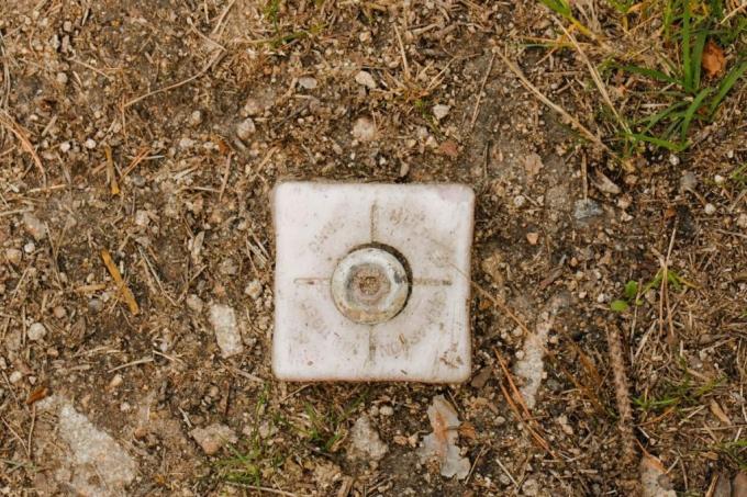
For decades, boundary stones have been used to mark property boundaries. They used to be made of granite. Today steel or brass bolts are used for marking. The property boundary results from the straight line between the boundary markings. Landmarks are often not recognizable at first glance.
Note: Boundary stones are official marks that must not be changed under any circumstances.
Boundary recovery
If a property line is no longer recognizable or If the boundary markings are missing, the land surveying office can make the boundary visible again by replacing boundary stones on the basis of the cadastral extract. A request is required for a boundary recovery.
Unclear borders
If you cannot find the boundary stones, the course of the boundary is not clear or there is a suspicion, that boundary markings have been moved, you can re-establish the property boundaries apply for.
It is the task of the land surveying offices to ensure that the land register and real estate cadastre match. They are organized differently in the individual federal states. Larger municipalities have their own land surveying offices. Check with the building authority in your city or municipality.
Procedure in the event of unclear boundary lines:
- Try to find the landmarks of your property.
- If these cannot be determined, request the border route from the responsible land registry or surveying office.
- If the border course is unclear, use a border action to obtain a judicial determination.
- After completing the assessment, have boundary markers set.
Note: If the property boundaries cannot be precisely determined by the land registry office, there is a so-called border confusion according to §920 of the Civil Code.

Boundary Assessment Agreement
If the authority is not able to determine the exact property line based on the real estate cadastre, the Local residents agree on a limit. The boundary course is defined by a surveyor within a boundary corridor. If the parties involved have given their consent, the measurement result will be recorded as a new border in a border assessment contract and included in the real estate cadastre.
Note: A border assessment contract can be concluded between neighboring property, but also ex officio between the municipality and property owners.
Limit distances
Even if the property line has been determined, you must observe spacing rules. These contain regulations for
- Buildings
- Plantings
- Overgrowth and undergrowth
- Removal of fallen leaves
frequently asked Questions
The cost of measuring a plot of land and setting the new boundary stone is around 1500 euros. You can apply for a remeasurement at the city administration's land surveying office.
The distance rules of the federal states contain limit distances for planting with hedges. Usually a distance of one meter to the property line must be kept for hedges that are more than two meters high. Exceptions apply to hedge plantings directly on the property boundary and to hedges that are located directly behind a boundary structure and do not protrude above it.
If the boundary is clear, property owners can request that the owners of the adjacent properties help finance the redesign. The legal regulations for border marking can be found in Section 919 of the German Civil Code.
